Syracuse, N.Y. -- Upstate New York is likely to get hit this weekend by a storm similar to the one on Tuesday that uprooted trees, cut power to tens of thousand of people, and brought a coating of wet snow followed by heavy rain.
The weekend storm could again deliver damaging winds and also drop potentially heavy lake effect snow at the east ends of Lake Ontario and Lake Erie, the National Weather Service said. The lakes are unusually warm for mid-January and relatively ice-free; the warmer and more open the lake, the more lake effect snow.
“While it continues to remain too early to pinpoint the exact specifics, the pattern supports the possibility of significant snow amounts for areas east of the lakes,” the weather service office in Buffalo said. “Additionally, windy conditions will persist through out the weekend and support areas of blowing snow.”
The weather service this afternoon issued a winter storm watch this weekend for much of Western New York, including Orchard Park, where the Bills play. The watch, in effect from Saturday afternoon through Monday morning, said more than 7 inches of snow are possible over the weekend, with winds possibly reaching 60 mph.
Lake effect snow can fall in narrow bands and thus be particularly tricky to forecast. Computer models used by meteorologists, however, hint lake effect snow for the Buffalo Bills playoff game on Sunday at Highmark Stadium, in Orchard Park.
Before that big storm arrives Friday, a fast-moving clipper system will slide across Upstate New York today, That could generate some light snow across much of Upstate New York. The Tug Hill region could get a foot or more as cold air streams across Lake Ontario.
The real action starts Friday night, when the center of a strong storm system coming out of the Midwest will pass to the west of New York. That means Michigan will be pounded by snow, but Upstate New York will again be on the storm’s warm side to start. Friday night with light snow followed by rain as temperatures rise.
High winds Friday evening and Saturday morning could bring another round of power outages. The weather service has already issued a high wind watch for Friday afternoon to Sunday morning for most of Western New York. Winds will again be from the southeast, at least at the beginning of the storm, and gusts could reach 60 mph Friday night and Saturday.
“Damaging winds could blow down trees and power lines,” the weather service cautioned. “Widespread power outages are possible.”
Southeast winds can be particularly damaging because trees in Upstate New York grow to brace themselves against the prevailing southwest winds. Rain and melting snow from Tuesday’s storm have saturated the soil, making trees even more vulnerable to being uprooted.
Flooding is also possible again this weekend as rain falls on melting snow. Nearly all of Upstate southeast of Syracuse is at some risk of flooding, although the Hudson Valley and Catskills are at greatest risk because that’s where the heaviest rain will fall on the heaviest snow pack.
Wind directions shifts to the west and southwest on Saturday just as the coldest air of the year so far surges in. The rain will change back to snow, and by late Saturday the lake effect snow machine could crank up. The strong winds will also blow snow around, reducing visibility and making driving difficult.
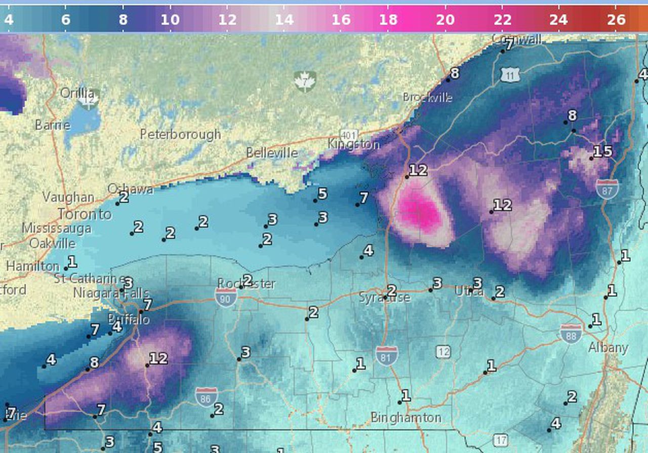
Western New York and the North Country could get heavy lake effect snow this weekend. This map shows the projected snowfall totals through Sunday morning, although more snow could fall after that.National Weather Service
A lakeshore flood watch has also been issued for Erie and Chautauqua counties. The wind could push water onto shore, causing flooding and shoreline erosion, the weather service said.
And after the wind and snow diminish, a blast of Arctic air is headed toward the contiguous U.S., including Upstate New York. It will be the most prolonged cold spell of the season so far in what is typically the coldest part of the year.
By Tuesday morning, temperatures could drop into the lower teens, with highs only in the 20s. Another storm could bring light snow Tuesday and Wednesday.
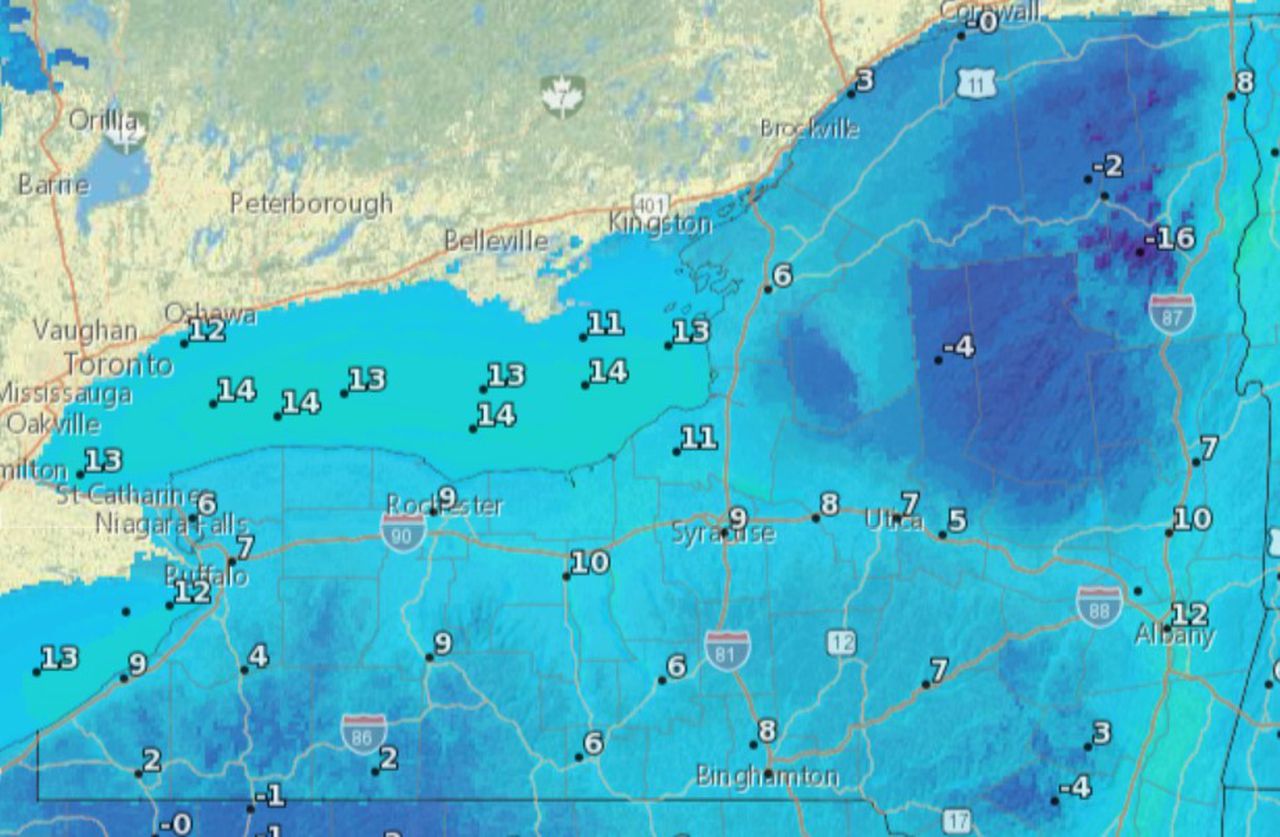
This maps shows the wind chill forecast for early Sunday morning across Upstate New York. Winds could gust to 40 mph.National Weather Service